The article below will talk about how to use Yandex.Navigator. Already from the name of the program you can guess its purpose. The essence of the utility's operation is to determine the user's current coordinates using signals from satellites of the worldwide geo-positioning system (GPS) and cell towers of the mobile network. The reader will be presented with instructions for downloading, installation and initial settings of the navigator application. The process of entering data for a route and following it is also described in detail.
Brief historical digression
In general, the idea of using a device to help a car driver determine his location is far from new. The first predecessor of modern electronic navigation devices appeared back in 1920 in Great Britain.
The English version looked like a wristwatch. Special mini-rolls with printed maps of the area were inserted into them, which were scrolled manually.
In 1930, a mechanical navigator was introduced for use in automobiles. Progress did not stand still: in the new device, paper maps were scrolled automatically. Separately, it should be noted that the intensity of scrolling directly depended on the current speed of the car.
Of course, there was no talk of any satellites at that time. If the driver turned onto a new road, he had to manually replace one map with another.
The idea of using satellite navigation to determine location came about with the launch of the first Soviet satellite in 1957. It turned out that it is possible to use the signal reflected from the device to determine the coordinates and speed of an object.
In 1974, the first GPS satellite was launched in the United States, marking the beginning of the creation of a global positioning system.
General description of Yandex.Navigator
“Yandex.Navigator” is a free application that greatly simplifies the life of a motorist who finds himself in an unfamiliar area. Below you will find instructions on how to use Yandex.Navigator.
The main features of the program are as follows:
- Plotting a route from the current point to a specified destination.
- Voice prompts while driving.
- Building the best route between two points on the map.
- View the map offline.
- Search for parking in parking lots in major cities.
- Display information about traffic jams along the route.
- Voice search function.
The user interface of the navigator program is simple. It is not difficult for even an inexperienced user to master it.
Clearing history
Now let's figure out how to clear the search history if it is no longer needed. To delete this data, do the following:
- press the menu button in the form of three stripes;
- select “Settings” – “Clear search history” at the bottom of the list of options;
- confirm the action.
You can also clear the history in an alternative way (actions outside the application):
- go to the smartphone settings, “Applications” section;
- on the “All” tab we find the software we need and select it;
- on the application page in the “Cache” block, click “Clear cache”, then in the “Memory” block select “Erase data” to delete all data and actions performed by the user, including search history.
Working with the service is easy. Now, having learned the basic rules for setting up and using, you can easily build routes around the city and find out the necessary information about the movement of the vehicle.
System requirements
Before using Yandex.Navigator on your phone, you need to find out if the device meets the minimum system requirements. They are quite democratic. For comfortable operation of the navigation application, it is enough to use a mobile device with the following parameters:
- Processor with a clock frequency of 1000 MHz.
- Display with a diagonal of 4 inches (smaller is possible, but it will be difficult to see anything).
- Availability of Wi-Fi and GPS modules.
- Operating system – Android version 4 and higher (there is also a version of the program for use with iOS).
How not to get lost in the forest with a navigator on your phone? Review of GPS applications.
How to use a navigator in the forest so as not to get lost? On this page we will introduce two popular GPS applications that suit our requirements. First of all, let's try to determine whether they are suitable for remote areas and whether they should be trusted. And, most importantly, are they capable of anything at all?! Let's figure it out together...
By clicking on this link you will learn about the rules for using a smartphone in extreme conditions. About its capabilities, pros and cons. And not only this…
Installation on a smartphone with Android operating system
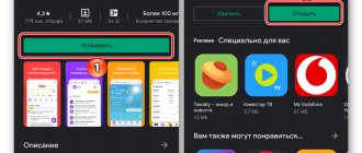
In order to install Yandex.Navigator on a smartphone, you need to perform the following list of manipulations:
- Launch the Google Play Market application store.
- Write the name of the program in the search bar (in our case, it is “Yandex.Navigator”).
- Click the magnifying glass icon.
- Tap on the “Install” button.
- Confirm permissions for the navigation program.
- Wait for the installation process to complete.
To start working with the installed Yandex.Navigator application, you need to go to the home screen of the Android system, find the required icon and tap on it to launch the program.
iGo
The application was posted on the Play Market and was found without any problems.
The package is, of course, wonderful. See for yourself:
Advantage: this is the simplest and most visually convenient navigator for driving. Reminds me of some kind of computer game. We hope that driving with it is just as easy.
Routing and other basic functions
So how to use Yandex.Navigator on Android? Below are brief instructions on how to use the functionality of the navigator application.
To start working with the program and make the initial settings, you must do the following:
- Launch the navigation program.
- Wait until the GPS module finishes determining its own coordinates.
- Touch the bottom of the smartphone display.
- A menu bar will appear. To search, click the magnifying glass icon.
- Set search parameters, find the desired address (or coordinates).
- Press the “Let’s go” button to start moving along the specified route. To change the scale, just touch the on-screen icons with a plus or minus.
- The color of the route line can change from green to red, depending on the intensity of traffic jams along the route of the car.
You can also select the type of map display in the settings. There are three options:
- Scheme. Displays maps compiled by cartography experts. There are street signs and house numbers. Various organizations are also tagged.
- Satellite. In this case, the background for the map is a satellite photograph of the area. Sometimes it’s easier to navigate an unfamiliar locality using a photograph.
- Folk. This category includes amateur maps created by Internet users. Their use is relevant in the absence of official versions of maps for the desired locality.
Other navigation application settings:
- Selecting the interface display type (day or night). In the second case, screen colors are inverted for better perception of information in the dark.
- Choice of voice accompaniment. You can choose one of three options: no voice, female, male.
Using maps offline
Many people working with the application have a question about how to use Yandex.Navigator without the Internet. Without access to the network, you can use maps downloaded in advance from the network. To download them to your device, you need to do the following:
- Activate the Internet connection on your mobile device.
- Launch the Yandex.Navigator application.
- Enter the main menu of the program.
- Select “Download maps” - “Search by city”.
- Next, you will need to enter the name of the city and download the proposed map file.
After downloading, the map will become available for viewing even without a network connection.
How to use the Navitel program
Like any other application, Navitel is downloaded from the Play Store. After installing and launching the program, a special “NavitelContent” directory is created in the device’s memory. Inside this folder, there is another directory called "Maps". It is in this folder that new maps should be uploaded.
After launch, the application automatically starts searching for satellites. When the smartphone connects to at least one satellite, the application will display the person’s approximate location on the map. The more satellites are involved, the more accurately the user's location will be determined. It should be recalled that the Navitel application is paid, but it is worth it.
Functionality available without an Internet connection
And yet, we need to finally clarify whether it is possible to use Yandex.Navigator without the Internet. It is difficult to give a definite answer to this question. Despite the use of satellite signals, positioning is also carried out with the participation of the Internet and Wi-Fi access points. In other words, without an active connection to 3G/4G networks, the navigation program will not fully function.
In such a situation, the user can only view previously downloaded maps of certain settlements, while active navigation and route guidance in offline mode are not available.
Auxiliary services
In addition to the satellite receiver itself, auxiliary settings are sometimes very useful for determining your location. As a rule, they are easily enabled on the phone itself:
- A-GPS. This service downloads your location data from the Internet using data from the cellular networks to which you are connected. Of course, its accuracy is much lower, but it speeds up accurate satellite determination.
- Wi-Fi. Didn’t you know that you can also determine your location using data from Wi-Fi networks?
- EPO. However, more about it below.
User reviews about the application
In general, before using Yandex.Navigator on a smartphone, it is wise to analyze reviews of the application from Internet users. It is possible that some operating features will make it impossible to use the program for a specific person.
According to users, Yandex.Navigator has both advantages and disadvantages. Let's list them.
Pros of the application:
- free of charge;
- fairly wide possibilities of use;
- excellent speed of operation of the navigation program;
- freely distributed detailed maps with excellent information content;
- more accurate positioning using the Wi-Fi module and cell tower signals;
- online traffic jam warning service;
- stability of the program.
Minuses:
- the application is only relevant for use in neighboring countries;
- Without a constant connection to the Internet, the Internet does not fully function, you can only view previously downloaded maps, but you cannot set a route or get information about traffic jams;
- sometimes incorrect information about the distance to the object is given;
- glitches that occur when working with the program (this drawback is subjective, taking into account the ratio of the number of downloaded copies of the application to the number of negative reviews on the network).
Waze
The developer positions Waze as a navigator that the Russian driving community helps develop. And, I must say, such collective support is beneficial for the application: many drivers switch to Waze from other navigators that they had previously used for years.
The program allows each traffic participant to add information to it themselves: report accidents, traffic jams, road works, traffic police ambushes, prices at gas stations and other things that may be useful to other users.
Waze features and functionality
Drivers value Waze for its up-to-date information, laconic interface, stable operation and, of course, free use. A big plus is that the program does not lose routes when Internet access is lost and automatically stops accessing GPS if not used during stops. This reduces the rate at which the battery drains.
Among the shortcomings of Waze, some users noted the lack of a 3D mode and voice search that does not always work correctly.
Summarizing
We think that thanks to this review, everyone was able to get at least a general idea of the capabilities of the navigation program from Yandex and the features of its functioning.
The Yandex.Navigator navigation program left conflicting impressions of use. On the one hand, we are pleased with the free distribution, excellent functionality of the application and the ability to plot a route according to given coordinates. If not for one big but... Firstly, in the absence of an active Internet connection, the application turns into a banal tool for viewing maps of settlements. Secondly, the program works fully (meaning with route planning and information about traffic jams) only in some neighboring countries. Thirdly, the overall functionality falls far short of monsters like Navitel. But despite these nuances, many users have made their choice in favor of freeness and simplicity; they are interested in knowing how to use Yandex.Navigator correctly. We hope that thanks to this review, everyone was able to get at least a general idea of the capabilities of the navigation program from Yandex and the features of its use.
OsmAnd or Maps.me. What's better?
In fact, both programs answer the question of how not to get lost in the forest with a navigator on your phone, clearly. That is, it is impossible to get lost with any of them. Of course, if the device itself is working properly and the application is in working condition. I mean timely loading of current maps and a number of necessary settings.
Let me remind you once again that my conclusions are purely subjective and do not claim to be the ultimate truth. In my opinion, OsmAnd is a more universal application. It has the same tools as Maps.me , plus track recording. During tests it behaved more responsively. However, this does not mean anything, because I conducted one test each. And to say for sure, a lot of tests need to be done.
If we talk about Maps.me , the application is completely free, which also means a lot. And the number of downloads can only be limited by the memory capacity of your device.
I suggest you test them yourself and draw your own conclusions. Or make a choice based on the geography of your movements. If you plan to travel throughout the country and don't want to pay, install Maps.me. If movement is limited only to your region, opt for the free version of OsmAnd .